Soundings in Betar, Bar-Kochba's Last Stronghold
Prof. David Ussishkin
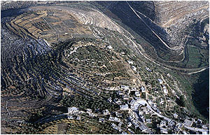
Fig. 1. Tel Betar, from south |
 |
Tel Betar (Khirbet el-Yahud) is situated southwest of Jerusalem near the Arab village of Bittir, its northern side flanking the Rephaim
Valley (Figs. 1-2). The Roman road from Jerusalem to Gaza passed in the valley to the north of the site. Betar is surrounded by deep
valleys on all sides except the southern side where a topographical saddle connects it to the hill to the south. The approach to the
settlement must have been from this side. The main source of water is a spring located to the east of the site.
Khirbet el-Yahud is unanimously identified with Betar, the last stronghold of the Second Revolt against the Romans, where its leader,
Bar-Kochba, found his death in 135 CE. The ancient name was
|
preserved in the name of the Arab village Bittir, and the Arab name of the site - Khirbet el-Yahud, that is "The ruin of the Jews",
keeps the memory of the Second Revolt. The identification is supported by the results of the surveys and the excavations.
|
The Roman siege of Betar in 135 CE, the conquest of the settlement and the slaughter of the besieged, including Bar-Kochba, which
put an end to the Second Revolt, is mentioned in both Jewish and Roman Sources - The Talmud and the Midrash, and Eusebius
(3rd-4th centuries CE) in his book on the history of the church.
The surface remains at Tel Betar and the traces of the Roman siege system were examined and analyzed by several scholars, V.
Guerin, C. Clermont-Ganneau, J. Germer-Durand, E. Zickermann, W.D. Carroll, A. Alt, A. Schulten, A. Reifenberg, S. Yeivin and others.
The interest of scholars focused on two problems: first, whether this site is indeed the last stronghold of Bar-Kochba as described in
the written
|
|
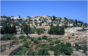
Fig. 2. Tel Betar, from east |
sources; second, assuming that this is Betar, what can be learnt from these remains about the Second Revolt and its final days.
During the 1970s Z. Yeivin, made soundings in Betar, but the results were not published. In 1984 Prof. David Ussishkin conducted a
trial excavation on behalf of the Archaeological Staff officer of Judea and Samaria and the Institute of Archaeology of Tel Aviv
University. Excavations were carried out in two fields located at the southern and western edges of the site; in both of them the
fortifications were studied.
Earlier Periods
Iron I-II pottery was found in previous surveys. Some Iron IIB-C pottery was found in the fills supporting the wall, including a storage
jar handle bearing a two-winged lmlk seal impression. Pottery from the Persian, Hellenistic and Early Roman periods was found in previous
surveys, and several Hellenistic coins were recovered in the excavations. It thus appears that Betar was continuously settled since Iron
I till the Roman period and that a settlement of some importance existed here during the later part of the Judean Monarchy.
Significantly, wall segments built of ashlars, one of them with ashlars dressed in characteristic Roman-Herodian style, were incorporated
in the later fortifications. These remains and the pottery indicate that a settlement of some significance existed here prior to the Second
Revolt.
|
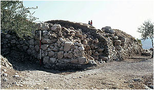
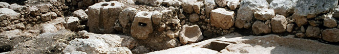
Fig. 3. A semi-circular buttress or tower in the city-wall |
|
The Period of the Second Revolt
The line of the fortification wall, dating apparently to the time of the Second Revolt, is visible along most part of the site and was studied
in the excavations. The northern part of the summit which was not settled was left outside the walled area. The city-wall was built as a
retaining wall, its lower part supported by a fill on the inside, thus resembling a terrace on the hilly slope. It contained several semi-circular
buttresses or towers (Fig. 3), and at least one rectangular buttress or tower on the western side. Apparently built in a hurry, the wall was
carelessly and inconsistently constructed.
|
Zickermann, Carroll and S. Yeivin suggested that a moat was constructed across the topographical saddle at the southern end of the site,
from which approach to the site was the easiest, but this seems unlikely. However, the southern end of the site was particularly fortified.
The ground here was elevated by dumping an artificial fill made of earth and limestone chips which also supported the wall, turning the
southern edge to the highest point on the summit of the site.
|
The pottery indicates that the site was settled in the 1st and 2nd centuries CE but not later. Many slingstones were recovered in the
excavations and on the surface (Fig. 4). A concentration of 22 slingstones was uncovered on top of the rectangular tower in the western
side. Two iron arrowheads, of the Second Revolt type familiar from the Judean Desert caves, were discovered on the semi-circular buttress
at the southern end of the site (Fig. 5).
The Siege System
S. Yeivin suggested that the long narrow heap of stones dumped in the saddle against the southern slope of the site and reaching half
|
|
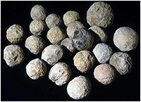
Fig. 4. Slingstones found on the city-wall |
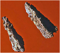
Fig. 5. Arrowheads found on the city-wall |
|
way up the slope is the Roman siege ramp. However, in recent years the 'siege ramp' has been damaged by the construction of a house
of the Arab village, revealing it to be a heap of stones dumped in recent times along the border between two agricultural plots.
The surrounding Roman siege wall, built of field-stones, was preserved along the western, northern and part of the eastern side (Fig. 6).
The siege wall crossed the Rephaim Valley and extended along its northern slope. It is probable that on the eastern side the siege wall
passed between Betar and the spring, thus cutting off the access of the besieged to their main water source. Two camps for the Roman
army units were built to the south of the site (Fig. 7). Other remains possibly associated with the siege were surveyed in the region.
Finally, a Latin inscription was carved in the rock near the spring by units of the Roman army stationed near the spring, apparently at the
|
time of the siege.
Summary: The Second Revolt
During the Early Roman period Betar was a modest settlement located near the road from Jerusalem to Gaza. It contained public buildings
constructed of ashlar stones. It is possible that some fortifications were built at that time, but not a circumvallating wall. With the outbreak
of the Second Revolt, Bar-Kochba chose Betar as his headquarters for four reasons: proximity to Jerusalem; proximity to the main route from
Jerusalem to Gaza; the abundant spring; Betar's topographical location on the top of a hill surrounded by deep valleys.
The main objective of the Roman army in conquering Betar was to eliminate Bar-Kochba and
|
|
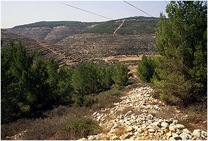
Fig. 6. Betar: The Roman siege-wall |
his men, rather than the conquest of the place. Two camps were built to the south of Betar where the approach to the settlement was relatively
easy, and a siege wall was erected around the site. Roman units stationed near the spring carved there an inscription in the rock.
|
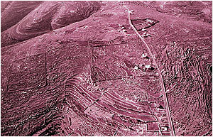
Fig. 7. Betar: The Roman camps |
|
To prepare for the impending Roman attack Bar-Kochba hurriedly constructed a fortification wall around the settlement. This wall was partly
founded on already existing buildings and fortifications. Specific attention was given to strengthening the southeast side where the approach
was easiest, but the northern, uninhabited part of the summit was left outside the wall.
Nothing is known of the battle itself. The Romen army stormed Betar without the need of a siege-ramp. The defenders made extensive use of
slingstones which were hurriedly hewn on the spot, and the battle was over before all the slingstones made ready on top of the wall were fired.
|
|
After the conquest the besieged were killed, and Betar was destroyed and abandoned.
|
Publications
D. Ussishkin, Archaeological Soundings at Betar, Bar-Kochba's Last Stronghold, Tel Aviv 20, 1993, pp. 66-97.
K. Singer, Pottery of the Early Roman Period from Betar, Tel Aviv 20, 1993, pp. 98-103.
|